Earth’s rivers, modest and mighty alike, all have humble beginnings in small rain-, snowmelt-, and groundwater-fed headwaters. These streams deliver nutrients and sediment to larger waterways downstream, provide critical habitat for numerous species, and make up more than 70% of total stream length globally. Yet they are among the least known components of river networks.
Gauges used to measure streamflow are disproportionately placed in large, perennial rivers, leaving headwater systems largely unmonitored.
This lack of knowledge stems in part from the fact that stream gauges used to measure streamflow are disproportionately placed in large, perennial rivers, leaving headwater systems largely unmonitored.
Better documenting and understanding these systems’ behavior could improve predictions of downstream effects of changing precipitation patterns and snowmelt timings, which are already subjecting communities to unprecedented risks including historic floods, droughts, and structural failures. It could also increase the accuracy of water availability estimates for agricultural planning, ecological water needs assessments, and downstream water quality management.
Novel monitoring approaches that document when water is present and provide flow estimates are beginning to fill data gaps for headwater streams. Pairing such observations with emerging hybrid modeling approaches, which combine physics‑based model components with data‑driven machine learning, could dramatically improve both understanding of headwater processes and fine-scale predictions of water availability in headwater systems.
Progress, until recently, has been limited mainly by the difficulties of bringing fragmented observations together and connecting observational and modeling research communities. But emerging tools and coordinated efforts are helping to overcome these limitations.
Bridging Gaps Between Data and Models
The contemporary study of headwater hydrology has advanced along two largely parallel tracks. Expanding observational networks, including community science programs and low-cost camera and sensor systems, are documenting when headwater streams flow and, in some cases, their approximate stage (water height) and discharge. At the same time, increasingly sophisticated physics-based models are simulating runoff, snow dynamics, and subsurface storage using the highest-resolution meteorological data available as input.
- Headwater streams across the United States occur in a variety of landscapes and have diverse characteristics. Whereas some flow all the time (perennial), others flow only seasonally (intermittent) or after storms (ephemeral). Likewise, some streams have relatively fixed paths, while others migrate. Headwaters also differ in their “order,” with hillslopes generating first-order streams that merge to form second-order streams, and so on. Here, an intermittent first-order tributary of Shaker Creek in Warren County, Ohio, runs over Ordovician limestone and shale in a suburban park. It has a drainage area of 1.2 square kilometers. Credit: Jay Christensen
- Kanarra Creek, a perennial third-order stream, runs through a sandstone canyon in Iron County, Utah, just northwest of Zion National Park and drains a 20.5-square-kilometer catchment. Credit: Jay Christensen
- An ephemeral first-order tributary of Salado Creek in Bexar County, Texas, drains a 0.1-square-kilometer area of Cretaceous limestone and marine sediment. Credit: Jay Christensen
- This dry, ephemeral second-order tributary in Little Rock Canyon in Utah County, Utah, drains 5 square kilometers amid the limestone bedrock slopes of the Wasatch Mountains. Credit: Samuel Christensen
- This perennial second-order tributary of Big Fiery Gizzard Creek in Marion County, Tennessee, drains an area of 2.5 square kilometers and flows through sandstone and shale of the Cumberland Plateau. Credit: Jay Christensen
- A perennial second-order tributary of Lookout Creek in Lane County, Oregon, drains a 1-square-kilometer area of weathered basalts in the H. J. Andrews Experimental Forest. Credit: Jay Christensen
Headwater modeling is still limited, however, by the spatial resolution of precipitation and snowmelt estimates, because small stream channels respond to spatial variability in weather that is often unresolved in current meteorological datasets. The coarse spatial resolution of soil and geological datasets, which capture landscape characteristics that influence streamflow, are also limiting. Bridging this mismatch of scales would help to increase the accuracy of headwater modeling.
Physics-based models capture basin-scale dynamics and water balances and offer the benefits of transparency and physical grounding in the laws of nature. However, they are often unable to resolve fine-scale intermittency in streamflows and extreme conditions in small basins. They also often rely only on stream gauges and do not incorporate irregular and heterogeneous data types more commonly collected in headwaters.
Artificial intelligence and machine learning (ML) models, which have rapidly improved weather forecasting, offer flexibility and can learn complex relationships directly from data. But most applications for stream hydrology depend heavily on continuous discharge records, which are typically sparse in headwater systems.
We still struggle to answer basic questions about headwaters in many watersheds such as, “Are the streams flowing today?”
Targeted data collection and modeling efforts demonstrate that headwater intermittency can be predicted regionally when the right data are assembled. For example, France’s Observatoire National des Étiages (ONDE) program coordinates systematic monitoring of intermittent tributaries across France, generating large-scale presence-absence datasets that have been used to evaluate climate sensitivity and downscale simulated runoff.
However, to date, the scope of such efforts has been isolated. Physics-based models and watershed-scale simulations covering areas broader than those considered in individual, localized studies rarely integrate flow presence-absence observations or community science records from small streams. Meanwhile, ML models are typically trained on continuous stream gauge datasets while ignoring other informative, grounding constraints.
Despite the availability of unprecedented modeling capabilities and expanding collections of observations, much of the available data about headwater streams remain fragmented and unused. The barrier has been less a matter of cost or technological readiness than of the effort required to integrate heterogeneous datasets and link observational and modeling communities that have historically worked separately. As a result, we still struggle to answer basic questions about headwaters in many watersheds such as, “Are the streams flowing today?”
Learning from Available Information
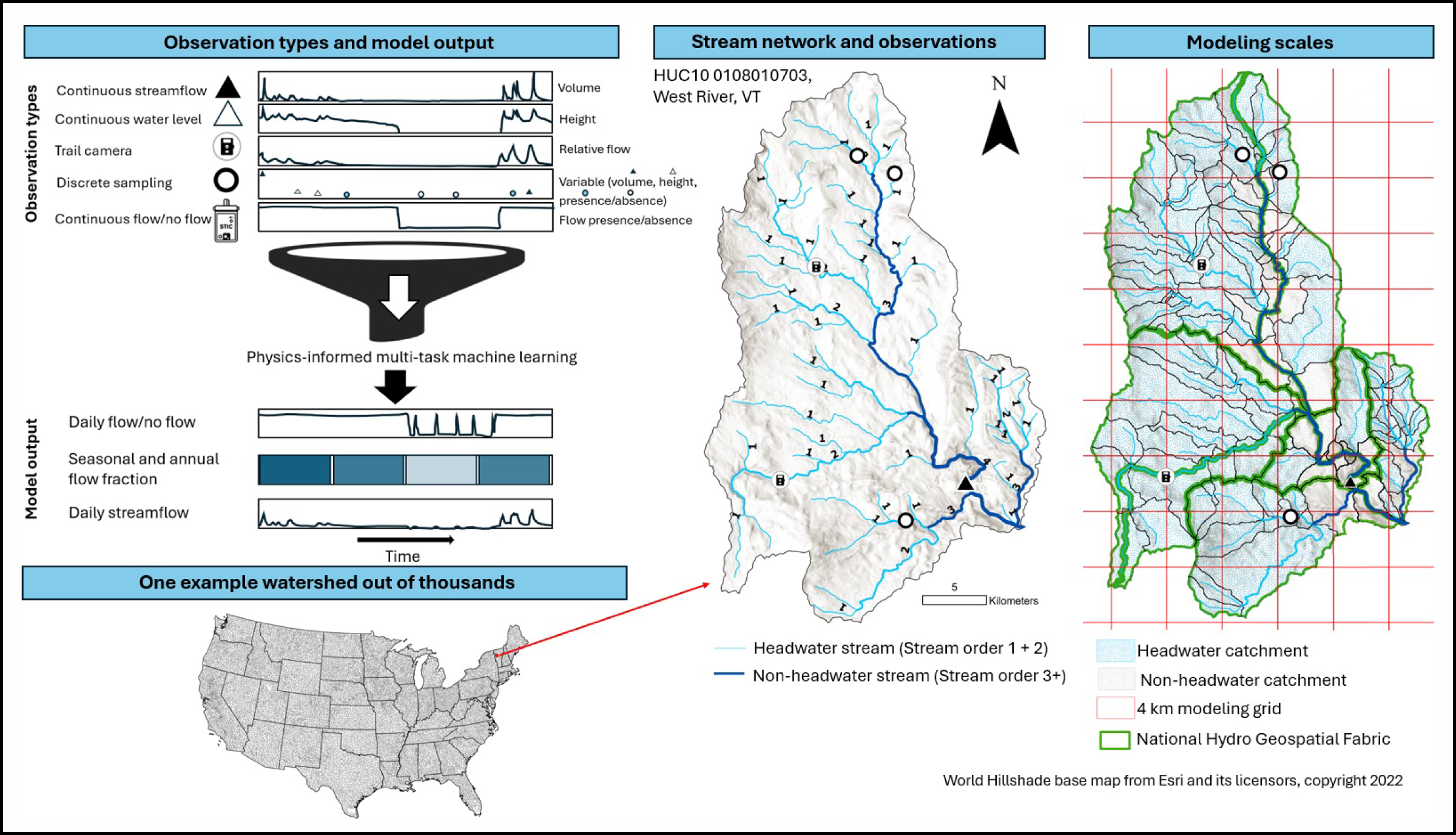
The most expedient opportunity to better understand headwater hydrology lies not in building entirely new systems to continuously monitor discharge—a standard unlikely to be met across all headwater systems—but in integrating data already collected and treating diverse observation types as complementary information (Figure 1).
Fig. 1. This figure illustrates different types of headwater streamflow observations as well as types of outputs from physics-informed machine learning modeling (left). Also shown are the flow network for an example watershed (middle)—the West River watershed in Vermont—and an overlay of modeling units on this watershed’s flow network, including the
National Hydro Geospatial Fabric (right). Diverse observation types combined with limited continuous monitoring data help estimate flow durations for all segments of the network. Click image for larger version. Credit: John Hammond
Continuous stream gauges capture the full temporal dynamics of flow on waterways, including during and after storms, revealing how and when flows rise, peak, and decline. Spot measurements, on the other hand, anchor hydrographs by quantifying flow at key moments.
Monitoring streamflow duration with data loggers and trail cameras provides additional data to models that augment more expensive streamflow data collected with stream gauges. The top photo shows data loggers and pressure transducers (yellow circles) deployed across the dry stream channel of Rossmoyne Creek, a second-order, intermittent stream in Hamilton County, Ohio, on 5 November 2021. A trail camera and barologger (red circle), which records barometric pressure and air temperature, were also installed on a bankside tree. The bottom photo shows a view from the trail camera, which was set to take a photo every 2 hours, on 13 November 2021. Click image for larger version. Credit: Ken Fritz
Community science programs document wet-dry status at many points in space using observations from passersby or low-cost wet-dry sensors. Camera-based systems validate intermittency and, with calibration, provide relative streamflow information. Each dataset is incomplete, with trade-offs in spatial footprint, temporal resolution, and measurement accuracy. Together, however, they describe hydroperiod (the pattern of days each year when water is present), connectivity, and flow dynamics far more completely than any one data type alone.
Beyond direct observational networks, remote sensing data—for example, from the Surface Water and Ocean Topography (SWOT) and NASA-ISRO Synthetic Aperture Radar (NISAR) missions—have potential for monitoring stream surface water indirectly, particularly where it is difficult to access. Headwater streams are often below detection levels for current satellites, but landscape-scale patterns in the water levels of neighboring water bodies may be reflective of headwater streamflow dynamics, providing information on when and where headwater streams are likely to be flowing.
Furthermore, depending on vegetation density and topography, high-resolution imagery and altimetry allow researchers to map surface water presence, estimate surface runoff patterns, characterize riparian vegetation, and detect changes in moisture or temperature patterns that signal hydrologic activity. By analyzing remotely sensed time series, scientists may be able to track how headwater streams respond to climatic variability, land use change, and disturbances such as wildfires.
Rather than replacing physics-based models with machine learning approaches, the two can be combined.
Modern ML architectures facilitate learning from these heterogeneous data types simultaneously, leveraging the different spatial densities of the relatively limited number of high-cost, continuous measurements at select locations and the vastly more abundant spot observations from community science efforts that often represent the only available streamflow information for an area. Rather than replacing physics-based models with ML approaches, however, the two can be combined.
Hybrid approaches can use physics-based outputs that capture watershed-integrated moisture state, snow water storage, and large-scale climate variability, but do not accurately predict headwater flows, especially low flows. Meanwhile, a data-driven component learns the ways that headwater reaches deviate from coarse-resolution estimates to make refined, fine-scale predictions.
Hybrid modeling has shown promise in other hydrologic contexts, and its ability to generate fine-scale predictions about headwaters can be evaluated explicitly. This sort of framework offers a way to integrate heterogeneous observations while remaining grounded in hydrologic reality.
Heading Toward a Hybrid Approach
An initial, achievable implementation of a hybrid headwater modeling approach would prioritize technically feasible and directly actionable metrics, namely, daily wet-dry classifications, seasonal counts of flowing days, and annual flow durations. These hydroperiod metrics underpin ecological processes, watershed connectivity assessments, and water quality management—even when discharge magnitudes remain uncertain.
Many streams experience dry periods because rainfall is minimal or due to increased evapotranspiration. In 2020, this small, unnamed, intermittent tributary of Rossmoyne Creek in Hamilton County, Ohio, flowed in May (left), was dry in July (middle), and then was flowing again in November (right). The stream drains a small urban catchment and is not shown on national stream maps. Credit: Ken Fritz
Multiple hybrid model architectures can support headwater prediction. Physics-informed neural networks can incorporate water balance information while focusing on tracking flow intermittency timing more precisely. Alternatively, tree-based ML approaches offer straightforward interpretability of the relative importance of environmental drivers and can readily incorporate mixed data types.
Both architectures could be configured to produce classification outputs (e.g., presence-absence, flow duration categories) and regression outputs (e.g., discharge magnitude, where reliable data exist).
As data compilation efforts expand and more observations become available, the same hybrid framework could later support increasingly sophisticated discharge predictions. Although the specific architectures that will exist in the future are uncertain, work to compile interoperable headwater datasets now ensures that future model advances can be rapidly applied.
Beyond predictive capabilities, models also create opportunities for discovery. By integrating and analyzing heterogeneous observations across different climatic and geomorphic environments, for example, models may reveal dominant controls on headwater intermittency (e.g., aridity, subsurface storage, or land cover or disturbance) and expose systematic biases in continental-scale water models.
From Idea to Operational Reality
The first step toward implementation of a hybrid headwater modeling framework is assembling multiple existing observational datasets.
Coordinating data compilation, standardizing workflows, and validating models among federal agencies, academic researchers, and regional watershed management organizations could effectively advance a hybrid headwater modeling framework from conceptual idea to operational reality. The first step toward implementation is assembling multiple existing observational datasets.
Initial efforts could focus on regions where flow observations are already available and observation densities are highest. The Pacific Northwest and upper Missouri River basin, where the U.S. Geological Survey’s Probability of Streamflow Permanence project has assembled extensive discrete flow observations, and the Chesapeake Bay watershed, where comparable observations have been compiled, are strong candidate pilot basins before methods are applied more broadly.
A fundamental but often underappreciated challenge at headwater scales is spatial referencing of data. Small stream channels do not typically align cleanly with gridded meteorological datasets used as model inputs, or with modeled watershed units or mapped hydrographic datasets. In some regions, channel heads migrate seasonally, and ephemeral tributaries may not be consistently represented in digital hydrographic maps.
These issues complicate the direct transfer of coarse-resolution model outputs to smaller spatial units. Scale mismatches between observation points, gridded data, and modeled spatial units are therefore a central consideration for any modeling framework operating at headwater scales.
Validation of headwater models could benchmark their predictive capabilities against standardized physics-based wet-dry and hydroperiod estimates, considering both gauged versus ungauged streams as well as predictions of both current and future conditions. And future conditions could be projected by forcing the hybrid models with downscaled climate projections and land use change scenarios, translating anticipated shifts in precipitation, snowmelt, and land cover into changes in the timing and duration of headwater flow.
The primary metrics for an initial implementation would, again, focus on basic understanding and forecasting of streamflow presence versus absence and on predicting seasonal or annual numbers of flow days within reasonable error bounds (e.g., 20%).
Scientists already have the essential ingredients for developing effective headwater models. What is missing is a systematic, interdisciplinary effort to deploy models that translate observations into fine-scale predictions.
Several research directions could receive further attention in later implementation stages. Improving discharge magnitude predictions at ungauged sites, for example, is critical and will require understanding of how well existing continuous measurements inform ML models and where denser observations might be needed. Developing methods to quantify uncertainty and communicate prediction confidence against specified reliability thresholds, especially when extrapolating beyond training conditions, could help strengthen predictions. Standardizing protocols for compiling diverse data, including procedures for quality control and metadata reporting, could also help.
Leveraging scarce data, modernizing approaches, and accelerating discovery in headwater stream modeling would benefit from a community of hydrologists, groundwater modelers, computer scientists, and social scientists working together across disciplines and organizations. For example, whereas key contributions of groundwater in headwater systems are often poorly understood and underrepresented in models, there is now potential to reveal groundwater behavior at finer scales, which would be supported by including groundwater expertise in modeling efforts. Shared tools, training, and collaborative spaces can help bridge these fields and build stronger communities of practice.
Scientists already have the essential ingredients for developing effective headwater models, including physics-based hydrological models, diverse observational networks, and powerful machine learning methods capable of integrating heterogeneous data.
What is missing is a systematic, interdisciplinary effort to compile existing headwater observations and deploy hybrid models that translate observations into fine-scale predictions. By coordinating this effort, headwater hydrology could become a predictive foundation supporting risk prevention for vulnerable downstream communities as well as needs for agricultural planning, environmental flows, and water management.
Acknowledgments
This work was developed in part from discussions by the Headwater Modeling Research Working Group at the John Wesley Powell Center for Analysis and Synthesis. We especially thank Ken Fritz for his help in providing images showing headwater stream sensor placements and wet-dry comparisons. The views expressed in this article are those of the authors and do not necessarily reflect the views or policies of the U.S. EPA but do represent the views of the U.S. Geological Survey. Any use of trade, firm, or product names is for descriptive purposes only and does not imply endorsement by the U.S. government.
Author Information
John Hammond (jhammond@usgs.gov), Maryland-Delaware-D.C. Water Science Center, U.S. Geological Survey, Catonsville, Md.; Jay Christensen, Office of Water, U.S. EPA, Cincinnati; Kristin Jaeger, Washington Water Science Center, U.S. Geological Survey, Tacoma; Roy Sando, Wyoming-Montana Water Science Center, U.S. Geological Survey, Helena, Mont.; and Jacob Zwart, Integrated Information Dissemination Division, Water Resources Mission Area, U.S. Geological Survey, San Francisco
Citation: Hammond, J., J. Christensen, K. Jaeger, R. Sando, and J. Zwart (2026), A hybrid approach for revealing headwater hydrology,
Eos, 107, https://doi.org/10.1029/2026EO260248. Published on 5 August 2026.
This article does not represent the opinion of AGU,
Eos, or any of its affiliates. It is solely the opinion of the author(s).
Text not subject to copyright.Except where otherwise noted, images are subject to copyright. Any reuse without express permission from the copyright owner is prohibited.